|
Station JJMC
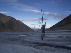
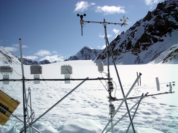
The JJMC met station on the ice surface
of McCall Glacier was established in May of 2003, at the location of a
prior station in the 1970s, near pole 2.4, across from the Hut and the
Hanging Glacier. This station records air temperature and relative humidity,
wind speed and direction, snow/ice distance, net radiation, snow moisture
at four depths, and ice temperature at 25 depths (down to 13 meters).
The original station was planted on poles 3 meters long, but the next
year it was replaced by a floating station. This site was selected both
for its prior history, as well as being a representative site in the ablation
area. It has a line of sight connection with the AHAB met station.
Click here
for the current weather.
Overview
Approximate coords (it's constantly
moving downhill):
UTM7: 387548 7692195 5313'
WGS84: 69.31579 143.85356 1714m
Program
May2003 - May 2004. It was updated in August 2003 to include freewave
radio telemetry.
Wiring diagram May 2003 to May 2004.
A major system overhaul occurred in
May 2004.
Program May 2004 - August 2004
Wiring diagram May 2004-August 2004
Program
August 2004 - Sept 2004
Program
Sept 2004 -
Wiring diagram Sept 2004 -
26 May 2003
The station was originally installed
about 26May 2003. It's original construction was based on two vertical
lengths of water pipe, each 20' long with a coupling in the middle. They
were sunk into the ice as deep as possible, and some cross braces added
to reinforce them. This arrangement worked, but was in general marginal
and ugly. The thermistor string was inserted exactly at the 1972 P2.4
coordinate. It turns out it likely should have been installed at the P2.5
coordinate.
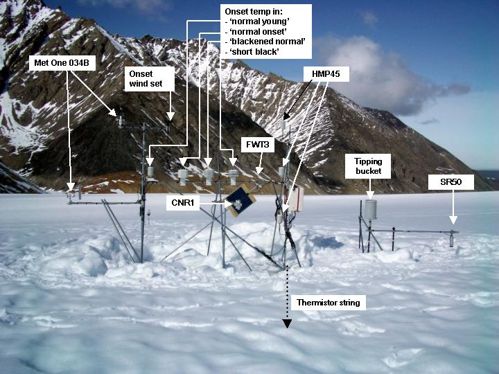
The original equipment installed included:
- CR10X: S/NX19139 1MB -55C cal 7/28/99
- AM16/32 multiplexor (for thermistors): S/N2792 new in 2003
- AT/RH at nominal 1m (Vaisala HMP45): 1.26m (note: not recorded in May;
calculated based on SR50 and offsets)
- AT/RH at nominal 3 m (Vaisala HMP45): 2.55m (note: not recorded in May;
calculated based on SR50 and offsets)
- Net rad: REBS Q98282; Sensitivity parameters: Top: 9.32 Bottom: 11.40
- Sonic ranger (SR50): 0.58 m
- Met One 034B wind set:
- 13.5 m thermistor string with 25 thermistors
- 40 W solar panel/ 90 AH battery
Coordinates: 69.31579731 -143.8534734
1714.995 (note: this is the rtk P2.4 location from 1972 with Z as ice
surface; the new station was not resurveyed after installation; note that
continuous GPS station FRED was located only a few meters away and continuously
logged x,y,z).

August 2003
- The anemometer was replaced with one with fresh bearings and calibration.
Cable messed with to decrease data drop-outs.
- The snow moisture probes were also reset into a framework such that
they will buried by snow as it accumulates (framework led to scour, such
that they were almost never buried).
- Leveled net rad
- Verified that 1 and 3 m AT/RH instruments are hooked to correct ports
- The telemetry system was also fully operational as of August 14 or so.
- A few days of poor data in August will be found the thermistor string
and the wind set, as some wires were knocked loose during installation
of the radio. This station uses a radomed omni antenna to communicate
with AHAB. No connection could be made directly to Kaktovik.
Instrument heights
- August 12, 3:30PM: Sonic ranger distance to ice measured as 1.67m (12
Aug)
- AT/RH 1 m nominal: 2.36 m (16 Aug)
- AT/RH 3m nominal: 3.65 m (16 Aug)
- Net rad: 2.16 m (16 Aug)
Coordinates: 69.31581832N -143.8533435W
1716.432m hae 14 Aug 03 (note: this is the Fred West coordinate, about
5 m away) Vertical is pole top.
May 2004
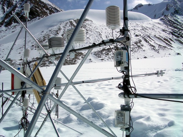
In May 2004, the structure of the station
was completely revised, with nearly everything installed on a floating
system. A 3m long crossbar at about 2m above the surface is part of the
structure, such that multiple air temperature sensors and shields can
be compared simultaneously. Two microloggers made by Onset Computer corporation
were also installed on the same structure, one with 4 air temperature
sensors (on the crossbar) and the other with a wind set (it also had a
silicon pyranometer, which failed before installation). This station was
erected at camp for a few days before installation at the proper location
on 25 May 2004 (9 PM); note that AT/RH probes were installed as 2m, 1m,
3m on mux for 3m, 2m, 1m on tower, respectively during that testing (17
May - 21 May).
Notes:
- Installed second mux (for HMP45ACs, FWTs): AM416 S/N 14384 -55C (never
used previously?)
- Installed new fine wire thermocouple (FWT3)
- Replaced HMP45AC sensors with freshly calibrated ones (Feb 2004)
- 3m HMP45ASP: S/N70620007
- 2m HMP45ASP: S/N70620015
- 1M HMP45asp: S/N70620014 (note: the field notes have two probes label
3m, this is my best guess at the 1m based on its later removal and placement
at the CORE site in Aug 2004)
- Installed onset micrologger "Air temp micrologger": S/N 753042
Model H21-002 (1 minute measure, 15 minute log, lithium batteries), launched
27 May 04 at 2PM
- micrologger AT sensor 749500: 'blackened normal' onset shield
- micrologger AT sensor 749506: inside normal Young shield from CS
- micrologger AT sensor 749510: inside 'short black' shield w/ upside
down plates
- micrologger AT sensor 749523: inside normal onset shield
- T107 reference thermocouple measured 0.25C in ice bath; unit taped to
mux, insulated, and battery left inside logger box to help stabilize temperatures
Old JJMC final instrument heights:
- pulled power 1:15PM 25 May 04
- SR50: 188cm
- verified 1m and 3m AT/RH labelled and wired correctly
- 1m AT/RH: 2.54m
- 3m AT/RH: 3.77m
- snow depth 50cm
- wind set: 4.25m (not recorded, best guess)
New JJMC instrument heights (most running
about 25 May 04):
- Note: the station was dug down to rest on ice surface, so all measurements
are relative to ice, even though 50 cm of snow surrounds the site and
probably drifted in after we left.
- Met One 034B (cup height): 1.70m and 3.05m
- Onset Wind Set (cup height): 3.05m
- 'normal young' (sensor height): 2.03m
- 'normal onset' and 'blackened onset' (sensor height): 1.97m
- 'short black' (nominal): 1.97m
- fine wire thermocouple: 2.0m
- AT/RH (1m nominal): 1.09m (sensor height)
- AT/RH (2m nominal): 2.06m (sensor height)
- AT/RH (3m nominal): 3.02m (sensor height)
- SR50: 0.48 m to ice (35 cm to snow, at installation, drifiting in was
likely)
- tipping bucket: 1.40m
- CNR1: 1.44 m to ice, roughly parallel to ice surface
Coordinates: 69.315919726N 143.853526974W
1714.931m hae 19 May 04 (note: vertical is north pole top)


August 2004
No major changes were made to the station
in August, except that the sonic ranger was set on a new pole and the
tipping bucket was moved onto the floating station.
Notes:
- the 1m AT/RH was removed (15 Aug 04 6PM) to be installed at the CORE
site, where we ran out of spares (note that this input port still read
values that were in the right range after the instrument was removed,
perhaps some latency from the previous ports?)
- installed two more FWTs (but forgot to program in final storage commands)
15 Aug 04
Instrument heights:
- no changes were made to instrument heights on floating station
- 6 thermistors exposed on thermistor string
- SR50 (installed 15 Aug 04): not recorded

JJMC in August 2004, as we found it. Everything was fine except the sr50
and tipping bucket, which were installed on the framework of the original
JJMC legs. It was a very hot summer.
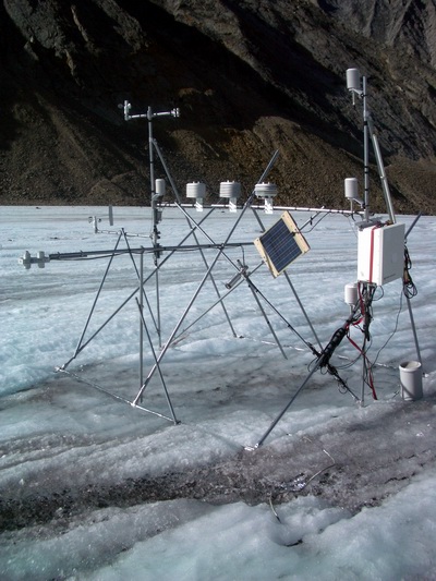
JJMC in August 2004, before the tipping bucket and sr50 were reinstalled.
September 2004
Made a quick visit here and installed
another 3m section of conduit to vertical post to create a profile of
5 fine wire thermocouples and replace the 1m AT/RH that was removed in
August.
Notes:
- Work started about 24 Sept 03 about 3pm and ended about 4pm
- Sonic ranger was found 1deg tilt towards hut and 9 deg tilt upglacier;
this support was stabilized further and leveled
- Installed new mast on east end of floating station for new FWT3s (five
total now)
Instrument heights:
- FWTs: 6.0m, 4.5m, 3m, 2m, and 1m (the last three are set to match the
height of the HMP45Cs, the first two are actual heights)

|