|
Home
Curriculum Vitae
McCall Glacier IPY
Lake El'gygytgyn IPY
Virtual Globes
IPY
DInSAR Soil Moisture
Photography
Older Projects
Personal
Contact
|
Research at Lake El'gygtygn
About 3.6 million years ago, a meteorite landed
in north-eastern Siberia, creating an 18 kilometer-wide crater that since
filled with 170 m of water and 350 m sediments. We believe that these
sediments hold a 3.6 million climate record of the Arctic -- the longest
continuous terrestrial arctic climate record by far. In fact, our previous
shallow cores (about 12 m deep) from there are already the oldest at 250,000
years. The project team consists of Russians, Germans, Americans, Austrians,
and Canadians. We have recently been funded through a consortium of national
and international funding agencies to extract a core throughout the entire
sediment thickness and into the shattered bedrock beneath. This drilling
project is scheduled to occur in spring of 2008. This project is part
of the endorsed IPY project called BIPOMAC.
Most of my research here has been to understand
the modern hydrological and limnological environment so that we can better
constain the paleoclimate interpretations. I've done this through a combination
of field work (trips in 1998 and 2000) and remote sensing of the lake
ice, though I am now getting into modeling interactions between lake ice
and lake water circulation. As part of our outreach work, I've created
a number of 3D visualizations
of this remote crater-lake. Recently I was funded by NSF to return to
the lake during the drilling project to investigate winter water circulation
within the lake and to model sublimation rates of lake ice to help us
determine whether the lake may have dried up in the past. I am facilitating
some data exchange on this page.
I have written two papers about my research here
thus far, and there are another dozen or so by the project team, many
of them in a recent special
issue in the Journal of Paleolimnology dedicated to our project.
Nolan, Matt
and Julie Brigham-Grette, 2007. Basic
hydrology, limnology, and meteorology of modern Lake El’gygytgyn,
Siberia. J. of Paleolimnology, 37:17-35.
Nolan, Matt, Glen Liston, Peter
Prokein, Julie Brigham-Grette, Virgil Sharpton, and Rachel Huntzinger,
2003. Analysis of Lake Ice Dynamics
and Morphology on Lake El'gygytgyn, Siberia, using SAR and Landsat.
J. Geophys. Research, 108 (D2) 8062, doi:10.1029/2001JD000934.
Our
Study Area: A Lake with the Oldest Terrestrial Climate Record of the Arctic,
Inside One of the Best Preserved Meteorite Impact Craters on Earth
The Elgygytgyn depression in northeastern
Siberia is the best preserved meteorite impact crater on earth for both
its size and its location in igneous target rocks. Soon after the impact
3.6 million years ago, the crater partially filled with a large lake.
The streams draining the crater watershed carry with them sediments that
contain proxy indicators of climate at the time of deposition. In 1998
we retrieved a 300,000 year old sediment core from the lake. We have since
analyzed the sediments, creating the longest terrestrial climate record
of the Arctic. A longer core retrieval is planned, which will hopefully
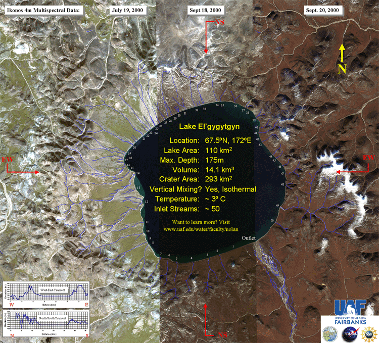
yield a climate record more than 3 million years old. At right is a mosaic
of Ikonos satellite images of the crater.
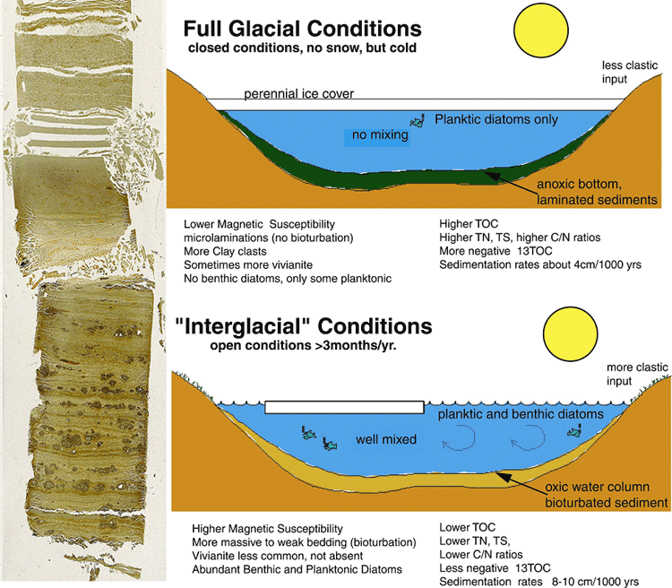
Lake Ice is the Dominant Control on Lake Biogeochemistry and the Sediment
Core Proxies
The 1998 core reveals distinct transitions
in most of the proxies, including sedimentation rate, laminations, diatoms,
pollen, magnetic susceptibility, and other biogeochemical markers on millenial
time-scale. These studies indicate that duration of lake ice cover particularly
whether it melts in summer or not is the dominant control on lake biogeochemistry,
because of the way it affects both mixing dynamics and dissolved oxygen
content. Knowledge of paleo lake ice cover duration is also a valuable
clue towards understanding paleo-climate. Understanding the modern hydrological,
limnological, and energy balance processes is necessary to fully interpret
the core record, because such observations provide our best opportunity
to link climate and proxy dynamics.
Satellite SAR is an Excellent Tool for Studying Modern Lake Ice Dynamics
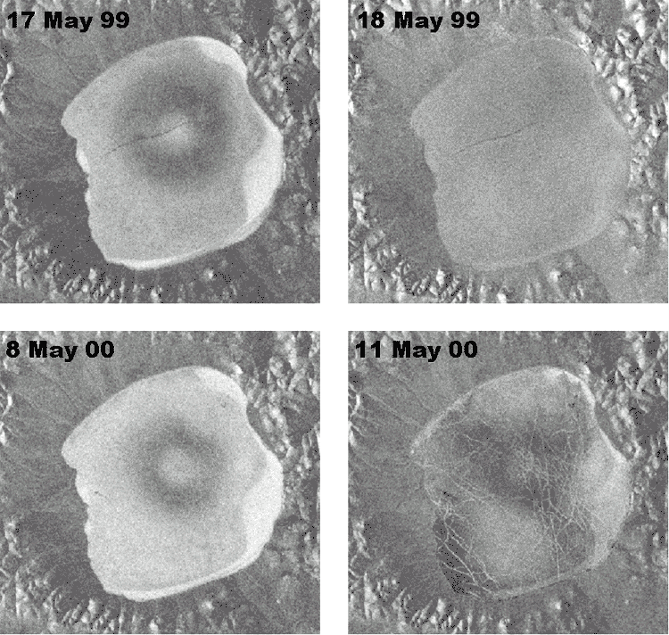
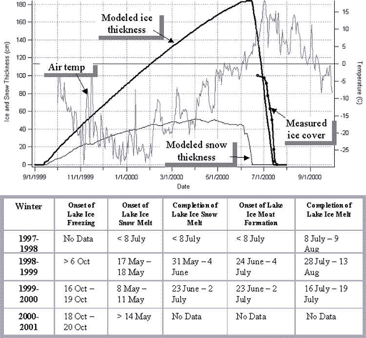
Based on over 400 SAR scenes, we have determined
the average dates of snow melt onset, ice melt onset and completion of
both over the past four years. Shown below is snow melt onset in two springs.
SAR microwaves penetrate through the dry winter snow and the dominant
backscatter signal comes from bubbles in the ice. Once the upper few centimeters
of snow begin to melt, however, the penetration depth is reduced to less
than the snow thickness (roughly 1 m), and the backscatter changes considerably.
During subsequent freezing events, the ice backscatter signal briefly
returns, validating our interpretation. From this strong signal response
we can determine snow-melt onset to within a single day in some years.
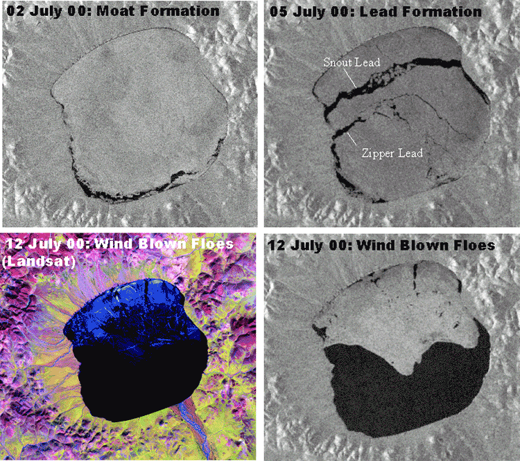
SAR is also an excellent
tool for observing the dynamics of lake ice break up. Seen here are scenes
of moat formation, lead formation, and wind-blown ice floes; a Landsat
7 scene is shown for comparison. We have compared these data to modeled
predictions of snow and lake ice dynamics with reasonable success (above
right). We can now use this model to hindcast the conditions necessary
to keep the lake ice from melting during the summer as part of the core-proxy
interpretations. Our observations from the past four years are summarized
in the table below.
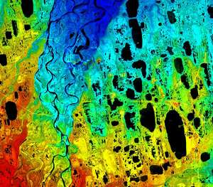
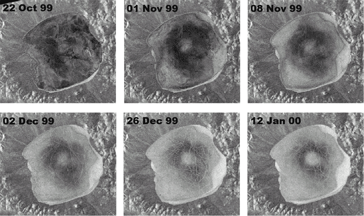
Variations in Ice Backscatter Indicate Regions of Increased Biologic Production
We also observed an interesting distribution of bubble scatterers within
the lake ice. Below is a time-series of SAR scenes showing the evolution
of this pattern. As the ice thickens (from below), more bubbles are entrained.
The shallow shelves have the warmest sediments due to solar radiation,
and therefore the highest biological productivity. This productivity increases
bubble formation due to increased respiration and decomposition, indicating
new uses for SAR in studying lake biota dynamics.
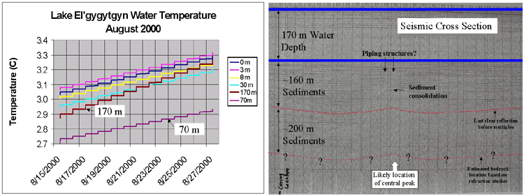
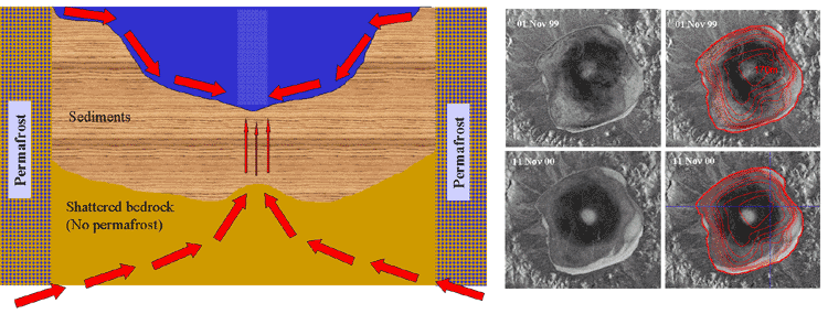
These Variations in SAR Backscatter May Also Indicate the Location of
the Central Peak of the Impact Crater, 500 Meters Below the Surface, Which
Has Important Implications for the Next Sediment Coring Location
Two mechanisms may explain the central bright
spot seen in the ice backscatter: density-driven currents from the shelves
and groundwater/gas upwelling. Because the shelf water is about 4ºC and
the bulk of the lake is near 3ºC, a density-driven current carries warm
shelf water (and its inhabitants) to the bottom (below left), causing
increased respiration and decomposition there. Because the lake is surrounded
by permafrost but not underlain by it, the highly shattered bedrock is
likely a conduit for groundwater and gas upwelling. Seismic evidence suggests
that piping structures exist within the sediments above the central peak.
Long-term, consistent upwelling there has consolidated the sediments,
possibly correlating the deepest part of the lake basin with the central
peak over time this has important implications for future coring projects.
The blue cross at lower right indicates the 1998 coring location; note
that it is not within the bright spot, possibly indicating it is in a
different biogeochemical regime, particularly during glacial times when
these density driven currents may have been established under the ice.
The darker area surrounding this bright spot varies yearly, possibly due
to the varying strength of the density-driven current from year to year.
|